Weeknotes: 19th August 2026
Last week
Both tardy and sparse weeknotes. Sparse as I had my second shingles vaccine last week which took me out for a day, but better a day feeling unwell now than a potentially unlimited amount of unwellness in the future.
Puntcon
My weeknotes are a little tardy because I was down in Cambridge briefly. On Sunday it was Puntcon, the somewhat annual get together of technologists, artists, and social scientist types (and anyone else who is interested). As ever, a fun time chatting to interesting people, and one idea that I need to find time to try prototype before I forget.
Habitat maps
I've continued to push along on the habitat map work. The UK maps are reasonably well refined now, but the UK is the beginner level/easy mode for this sort of thing: the UK is incredibly data rich, and so I need to start looking at other parts of the world now to see if my method is going to work in other areas or be useless due to a lack of data. To be clear, I'm not finished in the UK, but I feel I've de-risked the UK part significantly, so now I want to de-risk it going global. Ultimately, whilst it's nice it's showing promise in the UK, for the applications where I want to apply this work the UK isn't that interesting.
You can see the aforementioned data disparity if you look at this heat map of GBIF occurrences:
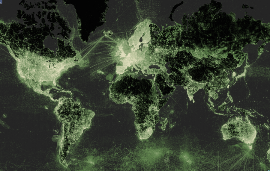
Similarly for OpenStreetMap data - as much as I adore OSM, you do see the availability of data fall of once you get outside populated areas. Even within Europe, when I was looking at the area around Kullberg, Sweden, to make a Minecraft map I found none of the buildings in that area were in OSM and I had to instead use the national buildings database.
As a concrete example of that data deficit and going back to GBIF, if I take occurrences of terrestrial vertebrate species in the UK I have around 80K points for 2024, but for Minas Gerais, one of the states of Brazil, which is 2.5 times the size of the UK, I have just 600 points for 2024.
The other challenge with operating outside the UK is it's harder for me to personally eye-ball the results and know if they're comically bad or not. Thankfully I've had some people come forward that can help me: Vinicius Tonetti has just joined the group I worked with on the LIFE metric, and he has experience with the Minas Gerais region (which is why I'm looking at it), and Anil connected me with Miranda Lam at Bangor University who is working with ground truths in Madagascar. I should say reconnected, as Miranda was working on the Tropical Moist Forest based project that I first started on when I joined the University.
I'm also being nudged to move to v2 of Tessera, which is in beta, over the v1.1 I'm currently using. Seems this is getting to the point where for early projects like mine it's good enough, and by the time I'm doing things seriously it'll be closed to production.
This week
- Tessera group show-and-tell meeting in Cambridge
- Meeting up with lots of other peopel whilst I'm in Cambridge
- Pressing on with the habitat map work outside the UK